Rolfe
Moderator
- Joined
- Apr 10, 2023
- Messages
- 12,316
- Reaction score
- 14,950
- Points
- 4,380
- Location (town/city + country)
- West Linton, Scotland
- Driving
- MG4 (2022-2025)
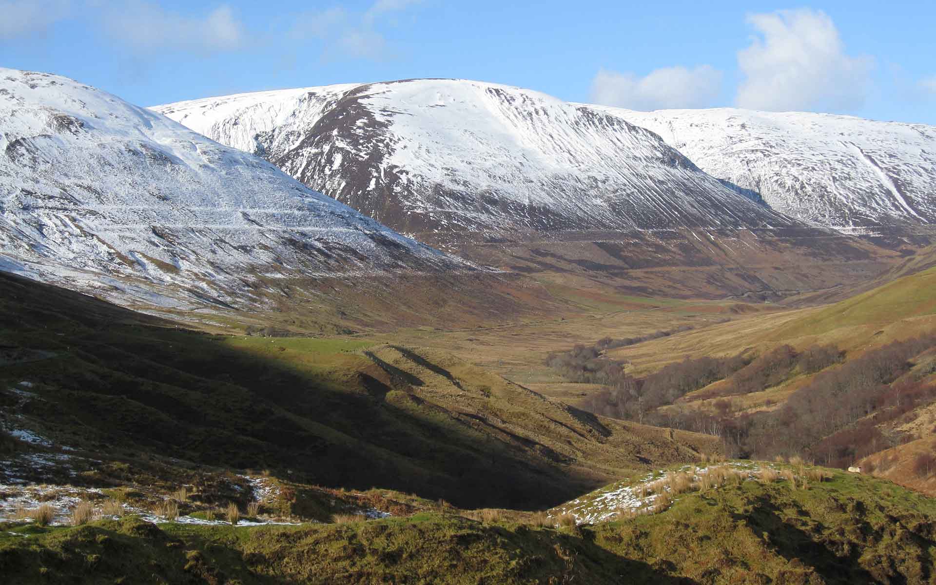
I spent a fair amount of time today reading up about the parallel roads. I had seen them marked on the OS map just like any other forest or moorland track, except they could be seen to follow the contours, rather obviously didn't connect to anything, and were specifically labelled "parallel roads". I was vaguely curious about what they were. I had no idea they were so famous. I only decided to ride Glen Roy because it looked like a nice bike ride!
For the first third of the ride, to the viewpoint, I had no idea. Then I read the blurb at the viewpoint (not every word at that stage) and the penny dropped. The rest of the ride was interesting as I was imagining I was at the bottom of this huge, cold loch at various depths depending on where the lowest unblocked exit channel was at the time. It was also particularly pleasant because the road was closed to traffic beyond the viewpoint, as workmen were installing new concrete bridges over three of the burns coming down the hillside. It was possible to cycle over them though (or walk the bike), and when I got to the third one the men were actively working with a huge HGV parked solidly in the middle of the road. I asked if it was OK to take a bike round, and they said sure thing, on you go. But it meant that I wasn't going to encounter traffic.
It was slightly eerie in that the broken clouds were quite dense, so the atmosphere alternated between bright sunshine bathing the glen, and ominous gloom. Although like all these Highland roads it undulated, the gradient wasn't much and I only had to walk one section near the beginning. I didn't go beyond Turret Bridge where the tarred road ends, as I'd had enough of rough tracks the previous day, but from all I've read it might have been interesting and I might go back some day.
I met another woman on an e-bike, a pretty sturdy chunky affair. While I was pushing Hilda up the steep part near the beginning she rode past me almost effortlessly, motor humming. She didn't look like Superwoman, and I thought, what the heck? But when I was standing around the viewpoint she came back the other way and came over to talk. (She had only been part of the way up the glen.) She told me it should be possible to get a bike past the bridge repairs, and all about her great-grandfather who had had a farm there with about a bazillion sheep, but went bankrupt and it was now derelict. Not a word about the parallel roads though!
So I asked her. Is that bike of yours the standard 250 watt motor? Oh no, she said, I think it's 650 watts. Well that explained her zooming up that hill. So do you have to have insurance and road tax and wear a helmet and all these extra regulations then? Oh no, she said, so long as it doesn't go faster than 15 mph. I'm pretty damn sure she's wrong about that! She said she needed it because she has a lung condition, and that's a really big point. So long as the motors are governed to cut out at 15 mph, what does it matter how powerful they are? It just means you can get up steeper hills without half killing yourself, and makes it easier for disabled or older people. But I really don't think that thing is legal. (She told me she has some mechanism to get it in the car, but it must be something like the Berlingo to take it.)
Back to the parallel roads. I can't imagine how anyone could think they were man-made. It's so hard to know how much I would have worked out for myself because I had speed-read the information board before I really started to think about them, but to me they just screamed loch shores. Yes I could see that mythical explanations might exist (Fingal again, natch), but to imagine they were made by mundane people (even nobility) is nuts. People don't excavate roads several metres wide that far up the side of a glen, they travel near the bottom by the river. Obviously. There is no record of anyone ever using them for travel.
Darwin's sea-shore explanation seems wildly implausible too, because the lines are so straight and narrow. Hey, tides? And rough seas and breakers? These lines look so much like the level shoreline of a relatively calm loch. And if it was the sea, why not in all the other glens in the Highlands? And where are the sea-shells? But none of these things dissuaded him at first because it all fit with his pet theory. But eventually he had to give in.
I was hoping to find a series of maps showing the different loch heights based on modern OS mapping (it's so easy to understand when you have access to that). But all I could find were figurative landscape realisations that don't show it so well. If only the OS mappers had used a distinctive symbol for the shorelines instead of marking them as if they were tracks it could be obvious even on the normal OS map, but as it is it's very hard to differentiate them from all the normal tracks in a lot of places.
The best short explanation I found was this one.
 iugs-geoheritage.org
The three loch levels being dictated by the heights of the three overspill cols (four if you count the 355-metre one where the top of Loch Gloy flowed down five metres into the top of Loch Roy above Turret Bridge) is the crucial point, which an entire BBC documentary I watched completely failed to mention.
I think the idea that the collapsing ice sheet allowed the water to drain "into Loch Ness and then into the North Sea" is just a mistake that is repeated in more than one article. The more thoughtful articles point out that the Great Glen was itself filled with ice at the time, one notes it as the (future) Great Glen, and diagrams that include it show "Loch Spean" being contiguous with Loch Lochy.
I usually have some reason to do the bike rides I choose, a literary reference or something, but I just picked Glen Roy off the OS map as being not too taxing and about the right length for a pleasant afternoon. I got more education than I bargained for.
For the first third of the ride, to the viewpoint, I had no idea. Then I read the blurb at the viewpoint (not every word at that stage) and the penny dropped. The rest of the ride was interesting as I was imagining I was at the bottom of this huge, cold loch at various depths depending on where the lowest unblocked exit channel was at the time. It was also particularly pleasant because the road was closed to traffic beyond the viewpoint, as workmen were installing new concrete bridges over three of the burns coming down the hillside. It was possible to cycle over them though (or walk the bike), and when I got to the third one the men were actively working with a huge HGV parked solidly in the middle of the road. I asked if it was OK to take a bike round, and they said sure thing, on you go. But it meant that I wasn't going to encounter traffic.
It was slightly eerie in that the broken clouds were quite dense, so the atmosphere alternated between bright sunshine bathing the glen, and ominous gloom. Although like all these Highland roads it undulated, the gradient wasn't much and I only had to walk one section near the beginning. I didn't go beyond Turret Bridge where the tarred road ends, as I'd had enough of rough tracks the previous day, but from all I've read it might have been interesting and I might go back some day.
I met another woman on an e-bike, a pretty sturdy chunky affair. While I was pushing Hilda up the steep part near the beginning she rode past me almost effortlessly, motor humming. She didn't look like Superwoman, and I thought, what the heck? But when I was standing around the viewpoint she came back the other way and came over to talk. (She had only been part of the way up the glen.) She told me it should be possible to get a bike past the bridge repairs, and all about her great-grandfather who had had a farm there with about a bazillion sheep, but went bankrupt and it was now derelict. Not a word about the parallel roads though!
So I asked her. Is that bike of yours the standard 250 watt motor? Oh no, she said, I think it's 650 watts. Well that explained her zooming up that hill. So do you have to have insurance and road tax and wear a helmet and all these extra regulations then? Oh no, she said, so long as it doesn't go faster than 15 mph. I'm pretty damn sure she's wrong about that! She said she needed it because she has a lung condition, and that's a really big point. So long as the motors are governed to cut out at 15 mph, what does it matter how powerful they are? It just means you can get up steeper hills without half killing yourself, and makes it easier for disabled or older people. But I really don't think that thing is legal. (She told me she has some mechanism to get it in the car, but it must be something like the Berlingo to take it.)
Back to the parallel roads. I can't imagine how anyone could think they were man-made. It's so hard to know how much I would have worked out for myself because I had speed-read the information board before I really started to think about them, but to me they just screamed loch shores. Yes I could see that mythical explanations might exist (Fingal again, natch), but to imagine they were made by mundane people (even nobility) is nuts. People don't excavate roads several metres wide that far up the side of a glen, they travel near the bottom by the river. Obviously. There is no record of anyone ever using them for travel.
Darwin's sea-shore explanation seems wildly implausible too, because the lines are so straight and narrow. Hey, tides? And rough seas and breakers? These lines look so much like the level shoreline of a relatively calm loch. And if it was the sea, why not in all the other glens in the Highlands? And where are the sea-shells? But none of these things dissuaded him at first because it all fit with his pet theory. But eventually he had to give in.
I was hoping to find a series of maps showing the different loch heights based on modern OS mapping (it's so easy to understand when you have access to that). But all I could find were figurative landscape realisations that don't show it so well. If only the OS mappers had used a distinctive symbol for the shorelines instead of marking them as if they were tracks it could be obvious even on the normal OS map, but as it is it's very hard to differentiate them from all the normal tracks in a lot of places.
The best short explanation I found was this one.
The Parallel Roads of Glen Roy - IUGS
The three loch levels being dictated by the heights of the three overspill cols (four if you count the 355-metre one where the top of Loch Gloy flowed down five metres into the top of Loch Roy above Turret Bridge) is the crucial point, which an entire BBC documentary I watched completely failed to mention.
I think the idea that the collapsing ice sheet allowed the water to drain "into Loch Ness and then into the North Sea" is just a mistake that is repeated in more than one article. The more thoughtful articles point out that the Great Glen was itself filled with ice at the time, one notes it as the (future) Great Glen, and diagrams that include it show "Loch Spean" being contiguous with Loch Lochy.
I usually have some reason to do the bike rides I choose, a literary reference or something, but I just picked Glen Roy off the OS map as being not too taxing and about the right length for a pleasant afternoon. I got more education than I bargained for.
")


 In car bunk and tailgate awning also available.
